The KTMPO regional roadway system features 3,700 miles of roadway with 71 miles interstate, 107 miles of US highway and 135 miles of state highway. On average there are approximately 4,500,000 daily vehicle miles traveled. These roadways are vital to business, farmers, military deployment, manufacturers, health care, recreation, and throughput. Interstate 35 and US Highway 190 are the region’s two most significant facilities.

Interstate 35 is essential to the movement of goods and services within the state of Texas, as well as from Canada to Mexico. The 36-mile stretch through the Killeen-Temple region has an average of 85,000 vehicles pass through daily. IH 35 is currently undergoing facility upgrades from the Bell County line to the south to the northern extent of Bell County. Facility upgrades will include: expansion from 4 lanes to 6 or 8 lanes of traffic, one way service roads, bridge turnarounds, direct-connect bridges and others. Expected completion of these upgrades is the Spring of 2019.

US 190 serves Fort Cavazos, one of the nation’s largest military bases. With approximately 45,000 to 55,000 troops present in Fort Cavazos, there are approximately 278,000 members of military families and support personnel in the region. The 50-mile stretch through the Killeen-Temple region has an average of 36,500 vehicles pass through daily. Current upgrades include expanding the highway from 4 to 6 lanes in the Harker Heights and Killeen area.

The significance of US 190 has been acknowledged by the Gulf Coast Strategic Highway Coalition. The multi-state coalition, which includes Texas, Louisiana and Mississippi, was formed to pursue the transportation needs of the U.S. Army and National Guard. The results of the “Forts to Ports” study show a corridor from El Paso, Texas to Hattiesburg, Mississippi. US 190 was selected as the corridor of choice for point-to-point delivery of troops and military goods.

On January 26, 2017, the Texas Transportation Commission voted to approve the designation of a part of US 190 in Bell County as Interstate 14. The 25 mile section of US 190 from the east side of Copperas Cove to I-35 in Belton will now be I-14. The Fixing America Surface Transportation Act, signed in 2015, designated the Us 190 corridor from Brady to SH 63 in Jasper as a high priority corridor which would be designated as I-14 in the future.

TxDOT Project Update-January 2017

Interstate

US Highway

State Highway

Miles Traveled Daily

Congestion Management

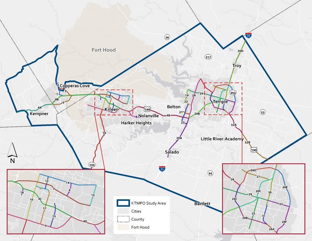
KTMPO has developed a Congestion Management Process (CMP) to identify congested roadway network in the region and assess possible mitigation strategies by collecting and monitoring the performance of the particular segments. The full CMP lays out the vision, goals, and objectives of the process, as well as an action plan for implementation. View or download the updated 2016 Congestion Management Process.

The CMP identified congested segments of the CMP Network, based on the results of the prioritization process. The list is separated into highway and areterial roadways of the CMP Network.

  1. US 190 from SH 9 to FM 3470/Stan Schlueter Loop
  2. US 190 from FM 3470/Stan Schlueter Loop to Business 190
  3. US 190 from Business 190 to IH 35
  4. IH 35 from Salado (FM2268) to US 190
  5. IH 35 from S Loop 363 to N Loop 363
  6. Loop 363 from Spur 290 to IH 35
  7. IH 35 from US 190 to S Loop 363
  8. IH 35 from N Loop 363 to Falls County Line
  9. Loop 363 from IH 35 to SH 36
  10. Loop 363 from US 190 to Spur 290
  11. SH 195 from Williamson County Line to FM 3470/Stan Schlueter Loop
  12. US 190 SE from Pritchard Rd to Milam County Line
  13. US 190 from FM 1715 to Business 190
  14. SH 36/Airport Rd from Loop 363 to SH 317
  15. US 190 SE from Loop 363 to Pritchard Rd
  16. Loop 363 from IH 35 N to SH 53
  17. Loop 363 from SH 36 to IH 35N
  18. Loop 363 from SH 53 to US 190
  1. Trimmier Rd from FM 3470/Stan Schlueter Loop to Hallmark Ave
  2. FM 3470/Stan Schlueter Loop from SH 201/Clear Creek Rd to US 190
  3. Business 190 from US 190 Bypass W to US 190 Bypass E
  4. Rancier Ave from Fort Hood St to Roy Reynolds Dr
  5. Fort Hood St from FM 3470/Stan Schlueter Loop to Rancier Ave
  6. SH 317 from US 190 to SH 36
  7. Business 190 from US 190 to Roy Reynolds Dr
  8. Loop 121 from IH 35 to Lake Rd
  9. WS Young Dr from Illinois Ave to FM 3470/Stan Schlueter Loop
  10. Ave D from N 1st St to Business 190
  11. FM 2305/Adams Ave from FM 2271 to 3rd St
  12. FM 2410 from US 190 to Warriors Path
  13. FM 1741/S 31st St from Canyon Creek Dr to SH 53/Adams Ave
  14. Willow Springs Rd from US 190 to Watercrest Rd
  15. FM 116 from Ave D to Elijah Rd
  16. Lake Rd from FM 2271 to SH 317
  17. Spur 290/ S 1st St from S Loop 363 to Ave E
  18. FM 93/Nolan Valley Rd from Wheat Rd to SH 317
  19. Spur 290/3rd St from Ave E to IH 35
  20. Hallmark Ave from Fort Hood St to Trimmier Rd
  21. 38th St from Business 190 to Rancier Ave
  22. N 2nd St from Hallmark Ave to Rancier Ave
  23. Industrial Blvd from Old Howard Rd to IH 35
  24. Roy Reynolds Dr from Business 190 to Rancier Ave
  25. SH 53/Adams Ave from 3rd St to E Loop 363
  26. FM 2271 from Lake Rd to FM 2305/W Adams Ave

My35 Waco District Map

My35 provides a useful way to look up current construction zones, closures, and incident alerts with this Traveler Information Map

Current Traffic Conditions

Traffic Cameras